River Landforms
By Alex Jackson
Last updated on
Potholes
Potholes are cylindrical holes drilled into the bed of a river that vary in depth & diameter from a few centimetres to several metres. They’re found in the upper course of a river where it has enough potential energy to erode vertically and its flow is turbulent. In the upper course of a river, its load is large and mainly transported by traction along the river bed. When flowing water encounters bedload, it is forced over it and downcuts behind the bedload in swirling eddie currents. These currents erode the river’s bed and create small depressions in it.

The creation of eddie currents as a result of bedload in a river.
As these depressions deepen, pebbles can become trapped in them. As a result of the eddie currents, the pebbles drill into the depressions making them more circular, wider & deeper. Pebbles will only be able to erode a river’s bed though if the rock the pebble’s made of is stronger than the rock the river bed is made of.
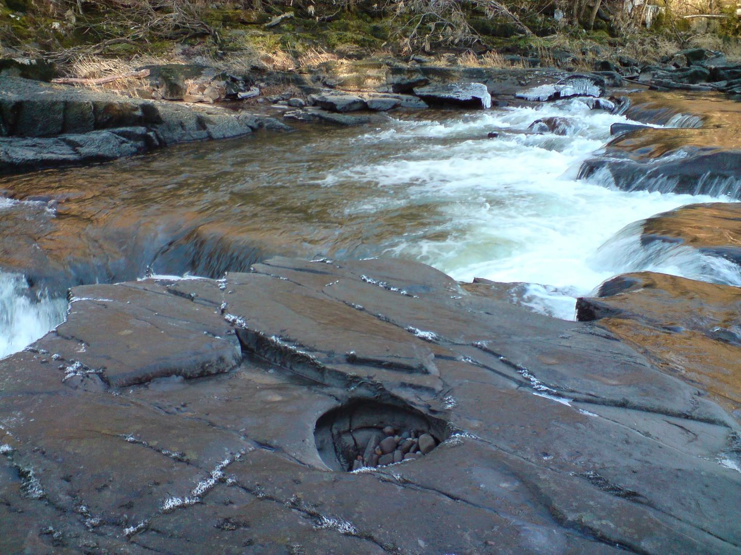
A pothole that has formed along the River Clyde.
Copyright Jim Ness. Licensed under the Creative Commons 2.0 license.
V-Shaped Valleys
V-Shaped valleys are found in the upper course of the river and are a result of both erosion by the river and weathering. V-Shaped valleys are deep river valleys with steep sides that look like a letter V when a cross section of them is taken, hence the name. They’re found in the upper course because this is where the river has the greatest gravitational potential energy and so the greatest potential to erode vertically. It does so during periods of high discharge. When the river’s discharge is high, it is able to transport its large bedload by traction eroding the river’s bed and valley by corrasion, deepening it. Not much lateral erosion takes place so the channel and valley remains relatively narrow.
As the channel and valley deepens the sides of the valley are exposed and become susceptible to weathering. The valley’s sides also undergo mass movements resulting in large volumes of material falling into the river’s channel, adding to its erosive power and causing the valley sides to take up a V shape. The steepness of the valley sides and whether the valley actually looks like a V is dependent on the climate, vegetation and rock structure among things. In cold, wet climates, freeze thaw weathering is abundant and rainwater can act as a lubricant, aiding mass movements. Vegetation can impede mass movements because it will help bind the soil. If the valley is composed of hard rock the valley sides will be very steep because they won’t be weathered easily.
Waterfalls (Geological)
Waterfalls develop when a change of lithology (rock type) takes place along the river’s course resulting in differential erosion. When the rock type of the river’s channel changes from a resistant rock to a less resistant one (e.g. granite to limestone), the river erodes the less resistant rock faster producing a sudden drop in the gradient of the river with the resistant rock being higher up than the less resistant rock. As the river flows over the resistant rock, it falls onto the less resistant rock, eroding it and creating a greater height difference between the two rock types, producing the waterfall.
When water flows over the waterfall it creates a plunge pool at its base and the splashback from the falling water undercuts the resistant rock. The unsupported rock is known as the cap rock and it eventually collapses into the plunge pool causing the waterfall to retreat upstream. Over thousands of years, the repeated collapse of the cap rock and retreat of the waterfall produces a gorge of recession.

Rapids
Rapids are sections of a river where the gradient of the river bed is relatively steep resulting in an increase in the river’s turbulence and velocity. They form where the gradient of the river is steep and the bed is composed mainly of hard rocks.
Meanders
Meanders are bends in a river that form as a river’s sinuosity increases. The sinuosity of a river is a measurement of how much a river varies from a straight line. It’s a ratio between the channel length and displacement (straight line distance) between two points in the river’s course:
\[ \text{Sinuosity} = \frac{\text{Channel Length}}{\text{Displacement}} \]
A sinuosity of 1 means that the channel is perfectly straight. A sinuosity greater than 1 means that the river meanders.
Meanders develop when alternating riffles & pools form along a river channel. A riffle is a a shallow section of a channel while a pool is a deep section. These riffles and pools develop at equal points along the river channel with each pool being about 5× the length of the channel.
In a pool, the channel is more efficient, while at a riffle, the channel is less efficient. This causes the flow of the river to become irregular and the maximum flow is concentrated on one side of the river. This increases erosion on one side of the river and increases deposition on the other causing the river’s channel to appear to bend. Erosion is greatest on the outside bend and deposition is greatest on the inside bend.

The alternating riffles & pools have another affect, they increase the turbulence of the river and produce a special type of flow known as helicoidal flow. This is a corkscrew like movement which spirals from one side of the channel to another between pools. The helicoidal flow erodes the pools along the channel and increases deposition on the next inside bend after a pool.
Characteristics
A cross section of a meander would show that on the outside bend, the channel is very deep and concave. This is because the outside bend is where the river flows fastest and is most energetic, so lots of erosion by hydraulic action and corrasion takes place. River cliffs form on the outside bend as the river erodes laterally. The inside bend is shallower with a gentle slip-off slope made of sand or shingle that is brought across from the outside bend by the helicoidal flow of the river. The river flows much slower on the inside bend so some deposition takes place, contribution to the slip-off slope.

Oxbow Lakes
Oxbow lakes are an evolution of meanders that undergo extensive deposition and erosion. As we’ve just seen, strong erosion takes place on the outside bend of a meander while deposition takes place on the inisde bend. As a result, the neck of a meander narrows. During extremely high discharge (e.g., a flood), it’s more efficient for a river to flow accross the neck of a meander rather than around it. When discharge returns to normal levels, the river continues follow this new course. The meander is left connected to the channel as a cutoff. Deposition eventually separates the cutoff from the main channel leaving behind an oxbow lake. With its main source of water disconnected, the lake eventually dries up leaving behind a meander scar.

Braided Channels
A braided channel is a type of channel that is divided into smaller sub-channels by small, temporary islands called eyots. Braided channels develop in rivers with a lot of sedimentary load, a steep gradient and where the discharge of the river changes regularly. When the volume of load exceeds the river’s capacity or the discharge of the river drops, the river is forced to deposit its load in the channel and islands of sediment (eyots) form.
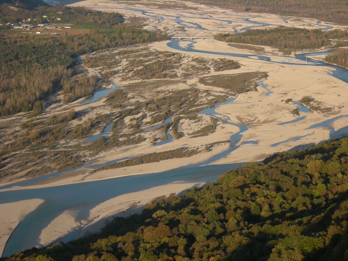
A heavily braided section of the Tagliamento’s channel in Italy.
Copyright Diego Cruciat. Licensed under the Creative Commons 3.0 license.
Floodplains
Floodplains are large, flat expanses of land that form on either side of a river. The floodplain is the area that a river floods onto when it’s experiencing high discharge. When a river floods, its efficiency decreases rapidly because of an increase in friction, reducing the river’s velocity and forcing it to deposit its load. The load is deposited across the floodplain as alluvium. The alluvium is very fertile so floodplains are often used as farmland.
The width of a floodplain is determined by the sinuosity of the river and how much meander migration takes place. If there’s a lot of meander migration, the area that the river floods on will change and the floodplain will become wider.
Levees
Levees are natural embankments produced, ironically, when a river floods. When a river floods, it deposits its load over the flood plain due to a dramatic drop in the river’s velocity as friction increases greatly. The largest & heaviest load is deposited first and closest to the river bank, often on the very edge, forming raised mounds. The finer material is deposited further away from the banks causing the mounds to appear to taper off. Repeated floods cause the mounds to build up and form levees.
Levees aren’t permanent structures. Once the river’s discharge exceeds its bankfull discharge1, the levees can be burst by the high pressure of the water. Levees increase the height of the river’s channel though, so the bankfull discharge is increased and it becomes more difficult for the river to flood.

Deltas
Deltas are depositional landforms found at the mouth of a river where the river meets a body of water with a lower velocity than the river (e.g. a lake or the sea). For a delta to develop, the body of water needs to be relatively quiet with a low tidal range so that deposited sediment isn’t washed away and has time to accumulate.
When a river meets a stationary body of water, its velocity falls causing any material being transported by the river to be deposited. Deltas are made up of three sediment beds that have been sorted by the size of the sediment. The bottom most bed, the bottomset bed, is composed primarily of clay and some other fine grained sediments. Clay is the main constituent because when clay meets salt water a process called flocculation takes place where clay & salt particles clump together (flocculate) due to an electrostatic charge developing between the particles. This makes the clay particles sink due to their increased weight producing the bottomset bed. The bottomset bed stretches a fair distance from the mouth of the river as the fine sediments can be transported a reasonable distance from the river’s mouth.
The foreset bed lies on top of the bottomset bed. The foreset bed is composed of coarser sediments that are deposited due to a fall in the river’s velocity and aren’t transported very far into the stationary body of water that the river flows into. The foreset bed makes up the majority of the delta and is dipped towards deep water in the direction that the river is flowing in.
The topset bed is, as the name suggests, the topmost bed of the delta. It too is composed of coarse sediment but, unlike the foreset bed, the topset bed doesn’t dip, it’s horizontally bedded.

Deltas can take on many different shapes. The three primary shapes of delta are cuspate, arcuate and bird’s foot.
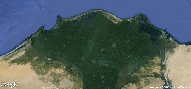
Arcuate deltas (e.g. The Nile Delta, Egypt) are shaped like a triangle (which is where the term delta comes from, the Greek letter delta Δ) and form when a river meets a sea with alternating current directions that shape the delta so that it looks like a triangle.
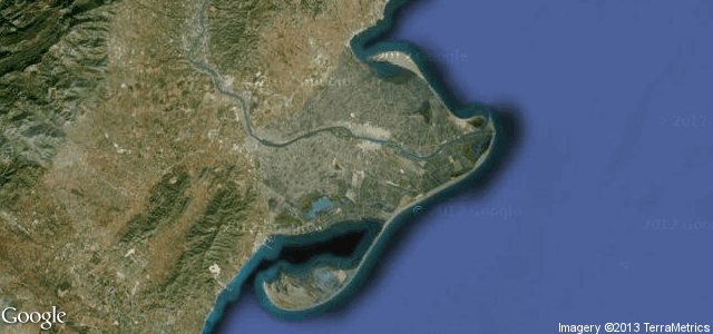
Cuspate deltas (e.g. Ebro Delta, Spain) are vaguely shaped like a V with curved sides. Cuspate deltas form when a river flows into a sea with waves that hit it head on, spreading the deposited sediment out.
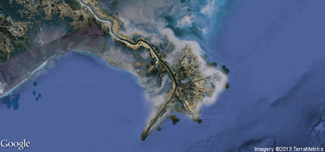
Bird’s foot deltas (e.g. The Mississippi Delta) are shaped like (as the name suggests) a bird’s foot. They extend reasonably far into a body of water and form when the river’s current is stronger than the sea’s waves. Bird’s foot deltas are uncommon because there are very few areas where a sea’s waves are weaker than a river’s current.
- This is the maximum discharge of the river before it will overflow its banks and flood.↩